Latency is the new resolution
Written by: Phil Cooper, AWS
A picture of our entire Earth’s surface is taken every day. Such a possibility—or even the concept—would have seemed unfeasible and unaffordable just ten years ago.
Yet now, with continued technology improvements, net new sensors, we are witnessing a rapid increase in the number of miniature satellites like SmallSats and CubeSats going into orbit, delivering a dynamic picture of our world.
Each of these satellites is capturing Earth observation (EO) data. Commercial companies like Maxar and Airbus, and government projects like Landsat from the U.S. Geological Survey and European Space Agency’s (ESA’s) Sentinel missions are delivering imagery intelligence to government, research, and the commercial sector at speeds and resolutions previously reserved for aerial photography. Multiple satellites can even be launched simultaneously as shown below by fleets from ICEYE, Planet Doves, Blacksky and the list keeps growing.
What Earth observation data can do to help the Earth
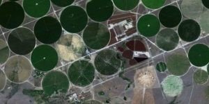
Circular Fields in Morrow County, Oregon
(photo courtesy PLANET)
The industry has arrived at a point long promised and until now undelivered. The demand for actionable intelligence is driven by EO data, and is now accepted by many industries including agriculture, insurance, utilities, and urban planning due to the consistency and reliability of the data.
Traditionally, a cartographer would deliver street-level mapping and all of the associated features and topography to support major country infrastructure projects through a highly manually intensive process. Today, with machine learning (ML), artificial intelligence (AI), and imagery from high-definition satellites, computers are able to learn how to identify and automatically generate maps and the features changing in this space through EO data.
High-resolution imagery from Airbus Plaeides constellation capturing imagery at 50cm resolution and the Maxar WorldView constellation at 30cm (in line with aerial photography) allows the user to identify and map key features on the ground and is broadly the norm. And medium-resolution satellite data, in particular the open data from the European Space Agency’s (ESA’s) Sentinel satellites, is providing data that can be accessed and used with no data costs, offering anyone the ability to track our changing Earth’s habitat. Yet the shift is coming from the end customer requests to have intelligence rapidly and less focused on that resolution, global surveillance is more common and so much is being developed on AWS cloud infrastructure to enable this now and while many of us in the industry advocate the value of EO, increasingly we are able to take that capability and drive on the latency element as we move forward as an industry.
Digital Earth Africa is making EO data more easily accessible, providing valuable insights for better decision-making related to prevention and planning in areas including flooding, droughts, soil and coastal erosion, agriculture, forest-cover, land use and land cover change, water availability and quality, and changes to human settlements.
GREENSPIN combines data, AI, and spatial web applications to make agricultural systems transparent and sustainable for smart farming providers, grain processors, and public authorities. BlueDot Observatory leverages open source EO data to keep an eye on our planet’s water resources.
How to get started with Earth observation data
Part of the revolution in EO is due to the lower cost of entry, and easier access to services enabled by AWS Ground Station.
Launched in 2018, AWS Ground Station is a fully managed service that lets you control satellite communications, process data, and scale your operations without having to worry about building or managing your own ground station infrastructure. Via AWS Ground Station, you can access Amazon services and benefit from the low-latency network of AWS Global Infrastructure. For example, users can store EO data in Amazon Simple Storage Service (Amazon S3), manage data ingestion from satellites through Amazon Kinesis Data Streams, and build custom machine learning applications for data sets through Amazon SageMaker. If you don’t have your own EO data or need to complement your own, Amazon Web Services (AWS) also has available a registry of open data with EO data.
Now with the repeatable, reliable, and consistent nature of EO data, we are starting to see its true value. Learn more about AWS Ground Station, Earth on AWS, and check out geospatial datasets available on the Registry of Open Data on AWS.


